The State of the World’s Amphibians report, published in 2023, presented an summary of the second Global Amphibian Assessment results, including analyses aimed at guiding future amphibian conservation planning and action.
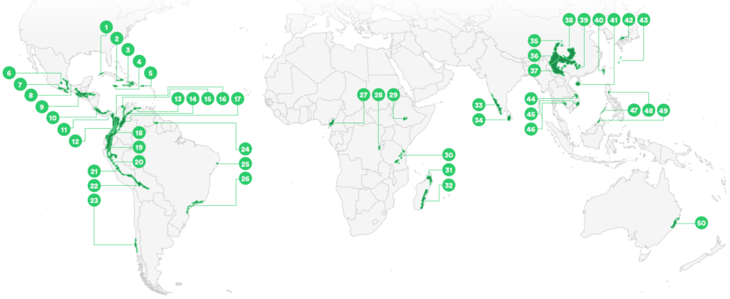
Using the richness map of globally threatened species and applying standardised criteria (see below), 50 Threatened Amphibian Landscapes (TALs) were identified for the first time. Although these landscapes combined cover only a very small proportion of the globe, together they contain 71% of all threatened amphibians, making them critically important for conservation.
Download the GIS data and the list of Threatened Amphibian Landscapes
Criteria for TAL selection
- – A cluster of at least five adjacent grid cells that each contain ≥4 threatened amphibian species. For island archipelagos, at least three or more neighboring islands that contain ≥ 4 threatened amphibian species.
- – When adjacent grid cell(s) with 3 species create a corridor between clusters, these cells are included.
- – If a cluster clearly includes more than one biogeographical area, it is split into smaller TALs accordingly.
- – Adjacent grid cells in under-surveyed areas likely to contain high numbers of threatened species may also be included.
Note: Species listed under Criteria A3 and E with disease identified as a future threat were omitted from the TAL identification process. Spatial resolution and projection: The ISEA10 grid is a geodesic discrete global grid system, defined on an icosahedron and projected using the inverse Icosahedral Snyder Equal
Area Projection. The hexagonal grid composed of individual cells retain their shape and area (864 km2) throughout the globe.
A complete list of TALs with summary data can be found in Annex 1, pages 80-81 of the State of the World’s Amphibians report.